Drone Magnetic Surveys or Drone Magnetometry is exactly what it suggests, a magnetometer flown beneath a suitable drone to enable a magnetic survey to be undertaken.
Magnetometers work by sensing tiny differences in the Earth’s magnetic field caused by subsurface materials/objects, and with some clever technology, can ignore the earth’s magnetic field and only concentrate on the detected differences.
These differences in field data are due to what is called magnetic susceptibility, which is directly proportional to iron content. The chemical formula for iron is ‘Fe’ after the word ‘ferrous’, which comes from the Latin word ‘ferrum,’ which means ‘iron’. Ferrous metals include steel, cast iron, and titanium, as well as alloys of iron with other metals (such as with stainless steel). Interesting to note, iron is often present in accumulations of non-ferrous ores, making magnetometry ideal for mining exploration.
The effects of the earth’s magnetic field vary around the world. Because magnetic fields are vectors, having a direction and a magnitude, the data results obtained by any given magnetometer for any given object, depends not only on the shape of the object, but on its location and the rock type that may be present at that location. There is also an added complication that some rock types provide their own local permanent magnetism.
Earth’s Magnetic Field varies across the globe
As a result of these variances in magnetic field around the world as well as the diurnal changes that need to be factored, there may be the requirement for a base station if the magnetic anomalies under survey are considered significantly small i.e., a diurnal correction may be necessary in an archaeological application, and superfluous if searching for buried well casings or Unexploded Ordinance (UXO).

Magnetometry is so effective because we have an excellent understanding of the earth’s magnetic field, so distortions can be corrected. A few examples of where Magnetometry is deemed useful and hence widely used, can be found below.
- Geology (stratigraphy/sediment analysis)
- Archaeology (buried objects, features, & architecture)
- Civil Engineering (utility mapping)
- Land Remediation & Redevelopment (area clearance)
- Mineral Exploration (iron, copper, tin etc.)
- Unexploded Ordinance (UXO) Detection (Landmines, IED, unexploded bombs & ammunition)
Magnetometers as used in drone magnetic surveys should not be confused with metal detectors. A magnetometer can be used as a metal detector, but it will only detect only magnetic (ferrous) metals. However, it is true to say that magnetometers can detect such metals at a much larger depth than conventional metal detectors; they can detect large objects, such as cars, at tens of metres, while a metal detector’s range is rarely more than 2 metres. It is also important to note that so called cultural noise, such as fences, passing cars, buildings, and other ferrous metals can interfere with the signals from the object you are attempting to detect with any given magnetometer.
The amplitude that the magnetometer is measuring decreases by the 3rd power of the distance. So, doubling the distance to the object, results in 1/8th of field intensity. For example, review the diagram below, at 3m AGL (bottom), we see only one large anomoly to the right, if we reduce the AGL to 1m (top), we see two large anomolies. In magnetics, the object’s depth and magnetic moment outweigh the field methods or technology used. The magnetic moment is the magnetic strength and orientation of the ferrous material or object that produces a magnetic field.
Inverse cube: Flying magnetometers lower gives better results

Magnetometer Key Features
There are several aspects that provide a good indication of the suitability of a magnetometer to support drone magnetic surveys. Here are a few of the key specifications that should be considered.
- Sample Rate: is the number of readings given per second. Sample rate is important for drone magnetic surveys; the sample rate and the drone speed determine the distance between measurements.
- Resolution: is the smallest change in a magnetic field the magnetometer can resolve. A magnetometer should be specified for the smallest change one wishes to observe.
- Noise: is the random fluctuations generated by the magnetometer sensor or electronics. Noise is given in units of nT.
- Bandwidth or bandpass: characterizes how well a magnetometer tracks rapid changes in magnetic field.
- Sensitivity: is the larger of the noise or the resolution.
- Dead zone: is the angular region of magnetometer orientation in which the instrument produces poor or no measurements. Important to assess when specifying a magnetometer.
Drone Magnetic Surveys
Drone Magnetometers have many benefits over cart-based surveys in some situations. It is fair to say that although airborne magnetometry is not replacing the precision achieved by cart surveys, recent technological developments mean that comparable results in some applications can be made. Regarding benefits, it is not just about the speed but also abut the safety of people in certain applications. Please see the following list of benefits and the reasons why drone magnetic surveys can be a great idea:
- Accurate survey lines (using RTK precision)
- Fast data collection over all terrains
- Smooth data collection without sudden sensor movements (due to uneven ground)
- Surveys over water and boggy terrain (unsuitable for cart)
- Surveys over dangerous land areas (mine fields)
- Surveys over slopes and precarious land features (safety perspective)
- New technology enables comparable results to cart based systems
- Provides scout capability to quickly evaluate large areas economically
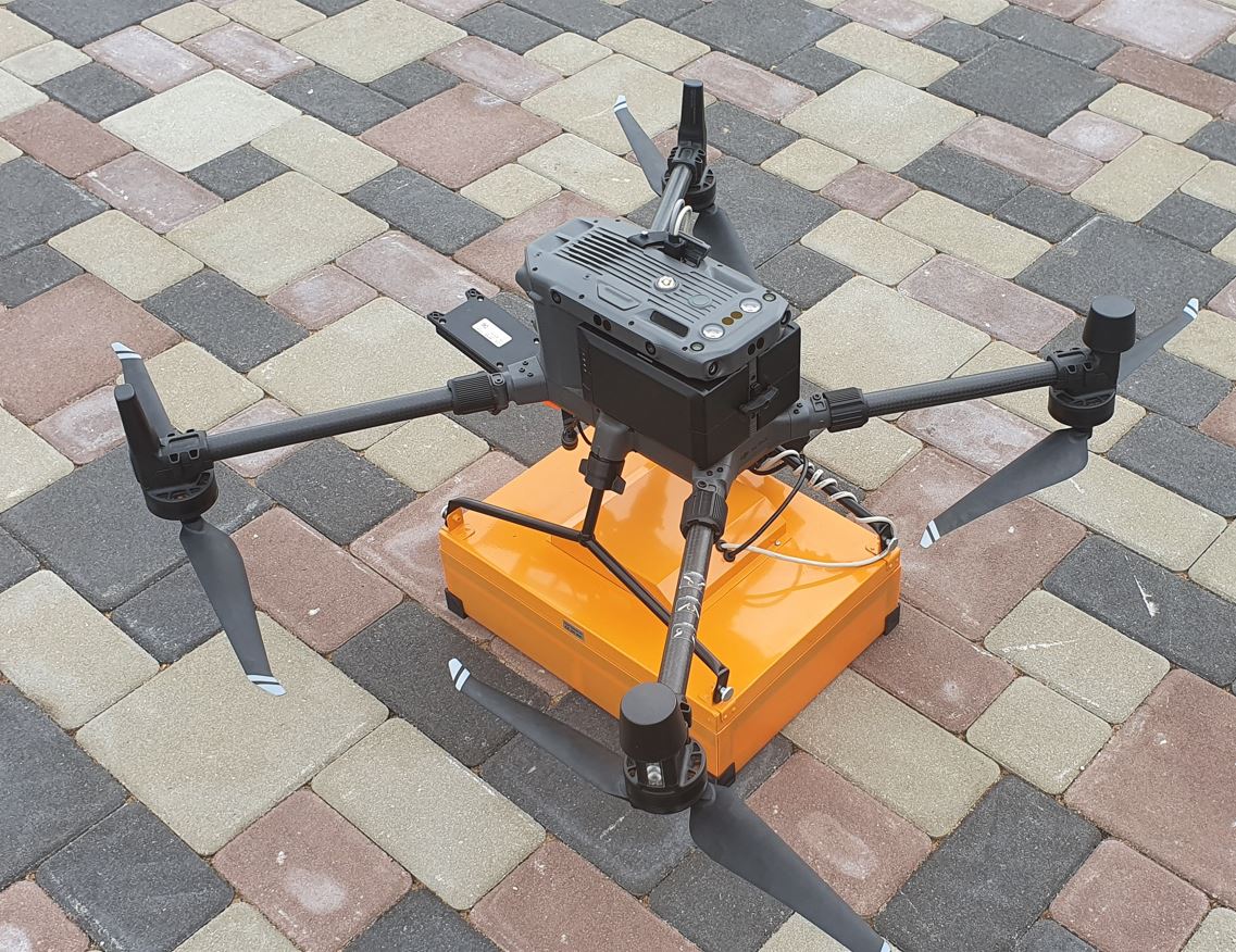
SENSYS MagDrone R3 & MagDrone R4 Magnetometers
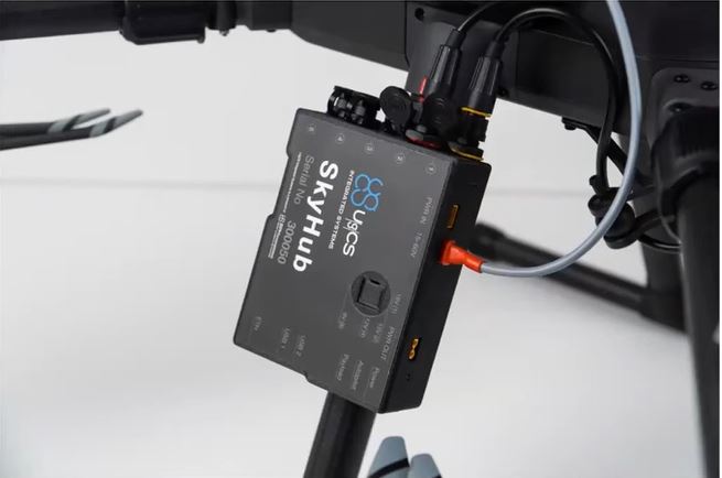
Both systems have been designed specifically for drone magnetic surveys. The MagDrone R3 and the MagDrone R4 should be operated with the UgCS SkyHub and UgCS True Terrain Following (UgCS TTF) system. This is because, when we consider that the amplitude of the magnetic anomaly for an object decreases as the inverse cube with distance, the closer you can fly these sensors to the ground, the better chance of resolving smaller magnetic anomalies. Flying either system with UgCS TTF enables the pilot to accurately fly the sensors as low as .5m over flat terrain, which enables the best results. Moreover, the UgCS TTF feature operates with a radar with a clever stability algorithm, that enables steady flight over light vegetation. The UgCS TTF is also effective over water (even water with waves).
SENSYS MagDrone R3 with UgCS SkyHub & TTF
MagDrone R3 v MagDrone R4 Considerations:
- Battery: The R3 can use its own battery, or the SkyHub via UgCS cable. MagDrone 4 has its own rechargeable battery.
- GPS: R3 with/without option – UgCS cable for without. R4 requires external source of GPS. UgCS SkyHub can record RTK values for both for inclusion in data sets (UgCS Geotagger Tool used in this case).
- Fuxgate Type: Both R3 and R4 use the same FGM3D/75 at 150pT. Sensor sensitivity of the two systems is the same.
- Fluxgate Distance: Standard for R4 is 50cm (arms unfolded), 25cm when arms folded. R3 is approx. 100cm. The R4 therefore provides better resolution than the R3.
- Pass Width: MagDrone R3 delivers 1.5m pass and is light and compact at 1.2kg. MagDrone R4 delivers 2.5m pass for less than 3kg weight (1.9Kg for new M300RTK version). M300RTK version does not fold, so 50cm spacing as per standard configuration
- Noise: Recent tests carried out by UgCS have shown that noise from the M300RTK is approximately 15nT. This unwanted noise can be cleaned using the smoothing filter (HodrickPrescott low-pass), found in the SENSYS data tool.
- Sampling Rate: MagDrone R3/R4 provide 200Hz (data points per second) standard sampling rate
- Flight Time: MagDrone R3 will give the M300 RTK user approx. 35 minutes of flight survey time. The MagDrone R4 will provide less flight time at approx. 25 minutes.
- Software: SENSYS provide users of R3/R4 with their own data tool for download and basic analysis. For data processing, UgCS kits can come with Magneto bundled.
SENSYS MagDrone Technology
SPH fly the SENSYS MagDrone R4 with UgCS SkyHub & TTF
UgCS SENSYS Magnetometer Systems
The SENSYS MagDrone R3 and SENSYS MagDrone R4 are flown in conjunction with the UgCS SkyHub and UgCS True Terrain Following (TTF) system. This system allows low AGL and better data to be collected during your drone magnetic surveys.
For further information on how UgCS can support the successful deployment of magnetometers, please see here.