What is Drone Ground Penetrating Radar (Drone GPR)?
Drone Ground Penetrating Radar (Drone GPR or Airborne GPR) is a geophysical survey method flown on a drone (UAV), that uses pulses of electromagnetic radiation to image below the ground surface. It is both a non-intrusive and non-destructive method of surveying the sub-surface. It is therefore a very useful survey technique to investigate many soils and materials. Examples include the ground, concrete, masonry, and asphalt.
GPR works by sending a tiny pulse of electromagnetic energy into a material and recording the strength and the time required for the return of any reflected signal.

A scan is a series of pulses over a single area. Whenever the energy pulse enters a material with different electrical conduction properties or Relative Dielectric Permittivity (RDP) from the material it left, part of the signal is reflected. The larger the contrast in the dielectric constants and conductivities of the two materials, the stronger the reflection. This means that an electromagnetic pulse which moves from dry sand (dielectric of 5) to wet sand (dielectric of 30) will produce a very strong reflection, while moving from dry sand (5) to limestone (7) will produce a relatively weak reflection. Because GPR works best when there is a big difference in the electromagnetic properties of the materials being surveyed, metallic objects buried in soils, make ideal targets.
Materials and Relative Dielectric Permittivity (RDP)
| Material/Soil type | RDP |
| Vacuum | 1.00 |
| Air | 1.00 |
| Snow (@ ρ=0,35 /350 kg/m3) | 1.57 |
| Clayey soil (dry) | 2.00 |
| Petrolium (crude) | 2.10 |
| Oil | 2.40 |
| Sandy soil (dry) | 3.00 |
| Ballast | 3.14 |
| Ice | 3.14 |
| Soil (frozen) | 3.14 |
| Soil (very dry) | 3.14 |
| Mica | 4.00 |
| Railway ballast | 4.60 |
| Granite (dry) | 5.00 |
| Polyethylene (PE) | 5.00 |
| Rock (dry) | 5.00 |
| Sand (dry) | 5.00 |
| Soil (dry) | 5.00 |
| Concrete | 6.00 |
| Sandstone (saturated) | 6.00 |
| Glass | 7.00 |
| Granite (saturated) | 7.00 |
| Limestone (dry) | 7.00 |
| Soil (rocky) | 7.00 |
| Basalt (saturated) | 8.00 |
| Limestone (saturated) | 8.00 |
| Average Normal Soil | 9.00 |
| Till/moraine | 11.11 |
| Soil (wet) | 14.00 |
| Clayey soil (saturated) | 15.00 |
| Cultivated soil | 15.00 |
| Shales | 15.00 |
| Sandy soil (saturated) | 19.00 |
| Soil (very wet) | 23.00 |
| Sand (saturated) | 30.00 |
| Silts | 30.00 |
| Soil (saturated) | 30.00 |
| Clay | 40.00 |
| Peat | 56.00 |
| Gyttja/mud | 60.00 |
| Water | 81.00 |
| Metal | 1000000.00 |
High RDP Complications
When we consider the table and the values for heavy soils and water, it is no surprise to learn that Ground Penetrating Radar will not work well in clay soils, particularly if they are waterlogged. Furthermore, the GPR signal is unable to penetrate through metallic objects, including very dense material reinforcement. This means that when the GPR signal (electromagnetic wave) hits a metallic target, a strong reflection would be expected with the rest of the signal energy being abated i.e. any objects directly below the metallic target, will not be detected for that scan. This is because the conductive properties of metal means any GPR signal will not pass through it but will instead resonate within it until there is no energy present. In essence, the greater the electrical conductivity of the subsurface materials through which a given electromagnetic wave (the GPR signal), must pass, the more reduced the penetration depth the wave will reach. It is worth noting that the power of the signal and its central frequency (as provided from the GPR antenna), will also have a bearing on the penetration depth.
Higher Frequencies = Shorter Wavelengths
Higher central frequencies provide a higher resolution but a limited depth. This means that GPR with higher frquencies can see smaller objects in greater detail than lower frequencies. Conversely, a lower frequency GPR provides greater penetration depth along with lower resolution. It is therefore rational to assume that depending on the application for which the GPR is being used, the correct central frequency must be used to get the best results. For example, it would be pointless using a 500MHz GPR for studying typical soil strata below 5m because the signal would simply not reach. However, using the same GPR to detect pipes buried at only 0.5m would be beneficial. In the same way, utilising a 125MHz GPR to detect small objects at 0.5m would be pointless as it would simply not have the resolution. However, the same GPR would be very effective for deep geophysical studies at 10m or more, where large sediment layers were being studied.

Drone Ground Penetrating Radar (Airborne GPR) Applications
There are a varied number of applications for where drone GPR could be the right tool in the toolbox. Here are a few of the more well know applications:
- Utilities Mapping – pipe detection and backfill identification
- Mountain Rescue – Avalanche Support for Search & Recovery
- Archaeology Surveys – Buried Artifacts and architecture search
- Land Conservation – Soil analysis, cavity, and sinkhole analysis
- Geological Studies – Rock thickness and state of structure
- Waterway Conservation – Fresh Water Bathymetry / Infrastructure Mapping
- Criminal Investigations – Buried remains location
- Artic Surveys – Snow, Ice & Permafrost thickness measurements

Drone GPR – Key Considerations
- ½ the signal strength of any flown GPR is lost though ground surface reflection which means heavy soils are not ideal.
- Heavy soils (clay and loam) are not at all friendly to airborne GPR. Wet heavy soils will provide poor results.
- An RDP less than 9 is required for effective results. Ideal UK soil conditions are dry sandy soils.
- Fresh water Bathymetry with airborne GPR is extremely effective and useful. However, it must be remembered that airborne GPR will not work in salt water.
Drone GPR – Fresh Water Bathymetry
Drone GPR utilises longer signal wavelengths that can penetrate 5-10m depth of water and even penetrate sediments below the riverbed or lakebed. For example, using a RadarTeam Cobra SE-150 with a central frequency of 125MHz, the GPR can take readings of a river’s depth, the depth of the soft sediments, the depth of the harder sediments below the softer sediments, and even the depth to bedrock. If the signal does not fully abate and can return signal due to a dielectric contrast being present (as discussed earlier), a detailed record deep in the earth can be recorded in the radargrams (aka GPR profiles). It should be remembered that Drone GPR will not work in salt water.

RadarTeam Cobra SE-150 (124MHz) Profile for River Lule
Types of GPR Use and their Central Frequency (MHz)
It is important to note that the central frequency is just that, a central frequency. Fact is, all GPR operate with a range of frequencies including the central frequency. However, for selection of a GPR, we use the central frequency. For example, for detailed concrete inspections where high resolution is required to see minute cracks, a GPR with a central frequency of between 1500-2500MHz would be used. For soil and utility investigations, anywhere between 500MHz and 1000MHz, could be used. And finally, for deeper geophysical investigations looking for large sediment changes at deeper depths, central frequencies of between 50 and 250MHz would be used.
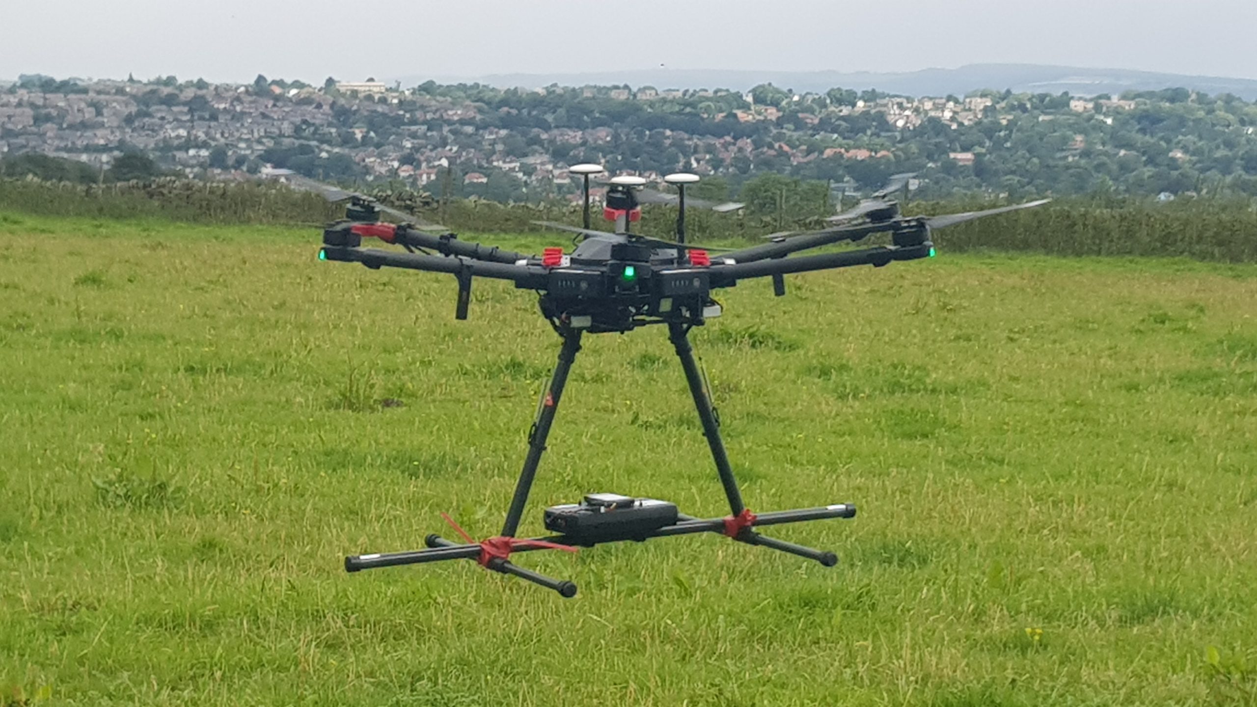
UgCS Drone GPR – Standard Range
| GPR | Center frequency, MHz |
| Radarteam Cobra Plug-In with SE-40 | 52 |
| Radarteam Cobra Plug-In with SE-70 | 80 |
| Radarteam Cobra Plug-In with SE-150 | 124 |
| Radarteam Drone CBD | 500 |
| Radar Systems Zond-12e Drone 500A | 500 |
| Radar Systems Zond-12e Drone 1000A | 1000 |
Note: Further Frequencies on Request to Suit Project Needs
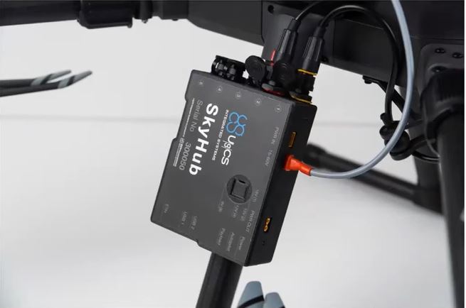
UgCS SkyHub & UgCS True Terrain Following (UgCS TTF)
The UgCS SkyHub solution is a hardware and software set designed to enhance UAV capabilities for commercial Ground Penetrating Radar (GPR) surveying and inspection purposes. In essence, it is the onboard computer that it is at the heart of your UgCS drone-based geophysical sensor system. Where the sensor is the Ground Penetrating Radar or GPR, the collected data will be geotagged and stored in the UgCS SkyHub. Further more, for maintaining an accurate AGL for your drone and sensor, the True Terrain Following Feature (UgCS TTF), and if fitted, the UgCS Obstacle Detection Radar (UgCS ODR), works with the UgCS SkyHub in complete harmony.
For more information on the SkyHub, TTF or ODR systems, click here.