Drone Methane Detection & Survey
Although drone methane detection & survey is a very important aspect of Green House Gas (GHG) emissions mitigation, it is also true to say that Methane sits alongside a few other critical gases that pose a serious risk to our future health.
Carbon dioxide (CO2): Carbon dioxide enters the atmosphere through burning fossil fuels (coal, natural gas, and oil), solid waste, trees, and other biological materials, and because of certain chemical reactions (e.g., manufacture of cement).
Nitrous oxide (N2O): Nitrous oxide is emitted during agricultural, land use, industrial activities, combustion of fossil fuels and solid waste, as well as during treatment of wastewater.
Fluorinated gases: Hydrofluorocarbons, perfluorocarbons, sulphur hexafluoride, and nitrogen trifluoride are synthetic, powerful greenhouse gases that are emitted from a variety of industrial processes. Fluorinated gases are sometimes used as substitutes for stratospheric ozone-depleting substances (e.g., chlorofluorocarbons, hydrochlorofluorocarbons, and halons). These gases are typically emitted in smaller quantities, but because they are potent greenhouse gases, they are sometimes referred to as High Global Warming Potential gases (“High GWP gases”).
Methane (CH4): Methane is emitted during the production and transport of coal, natural gas, and oil. Methane emissions also result from livestock and other agricultural practices, land use and by the decay of organic waste in municipal solid waste landfills.
A way of comparing these gases is to use a metric called Global Warming Potential (GWP). GWP allows us to compare how much warming a newly emitted gas will cause, relative to the same mass for Carbon Dioxide or CO2. The following data is taken from an IPCC support paper authored in 2018 and it gives a good indication of the effects of the gases over time. Over a 20 year period, methane gas is 84x more effective at warming our climate.

Focus on Methane
Methane can be characterised as a “super-pollutant”. While it stays in the atmosphere only for 12 years, it is up to 86 times more powerful in warming the climate in the short term than the most discussed greenhouse gas (GHG), carbon dioxide. Methane is also a major precursor for tropospheric ozone, which is harmful for human health and plant growth. While some 40% of methane is natural, about 60% of it originates from anthropogenic sources, mostly in the energy, agriculture, and waste sectors.

Paris Agreement 2015
Under the Paris agreement and subsequent global agreements, all countries are committed to updating their climate action plans – nationally determined contributions, or NDCs – at five-year intervals. Although the deadline for new or updated NDCs is at the end of this year, the postponement of the UN climate conference in Glasgow to November 2021 due to the COVID-19 crisis has given countries some leeway. However, the UK government is aware that they must be instrumental in supporting industry to reduce GHG emissions of which methane release plays a huge part. To enable this reduction, the UK regulator, the Environment Agency (EA), are keen to see new quantification methods commercialised and regulated. Of the new methods the EA are keen to regulate, drone methane survey is top of their list of ‘must haves’ and therefore, methane detection and measurement by drone is set to become a big market for drone companies within the next 10 years. Before quantification by drone can be fully regulated, the EA realises that commercial capacity needs to exist. This commercial capacity will need to have the technology and experience to progress from non-quantification techniques that can support ISO 14064 just now, to quantification techniques that can regulated to support the UK government’s budget requirements as set down in the Paris Accord 2015.
ISO 14064: Part 1 (2018), Part 2 (2019), Part 3 (2019)
Part 1 specifies principles and requirements at the organisation level for quantification and reporting of greenhouse gas (GHG) emissions and removals. It includes requirements for the design, development, management, reporting and verification of an organization’s GHG inventory. Part 2 covers provides guidance at the project level for quantification, monitoring and reporting of activities intended to cause greenhouse gas (GHG) emission reductions or removal enhancements. It includes requirements for planning a GHG project, identifying and selecting GHG sources, sinks and reservoirs relevant to the project and baseline scenario, monitoring, quantifying, documenting, and reporting GHG project performance and managing data quality. Lastly, Part 3 provides guidance for those conducting or managing the validation and/or verification of greenhouse gas (GHG) assertions. It can be applied to organizational or GHG project quantification, including GHG quantification, monitoring and reporting carried out in accordance with ISO 14064-1 or ISO 14064-2.
UK Cimate Change Committee (CCC)
For information on the UK’s pathway to zero emissions, please follow the link right here. This will take you directly to the website of the CCC who act as independant advisor to the UK government. Of particular interest will be the Sixth Carbon Budget advice report, which was required under the Climate Change Act. This document provides ministers with advice on the volume of greenhouse gases the UK can emit during the period 2033-2037. It sets the pathway to Net Zero and is based on an extensive programme of analysis, consultation and consideration by the Committee and its staff, building on the evidence published last year for our Net Zero advice.

Drone Methane Detection & Survey
JBUAS in partnership with SPH Engineering (UgCS) can provide a UAV methane detection & survey solution to support ISO16064 today with the same technology being utilised for regulated quantification. What this means in real terms is that one set of technology bought today will enable a drone survey company to perform surveys well into the future post EA regulation. Make an enquiry to find out more.
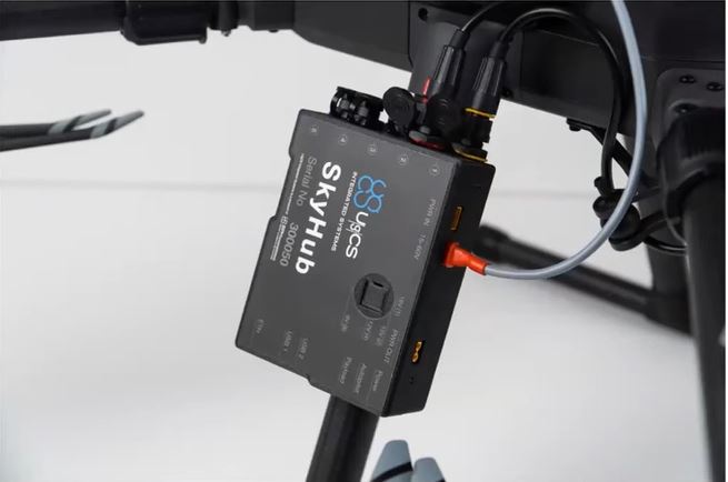
The system kit utilises the UgCS SkyHub and TTF System that is tried and tested with the DJI M210, M600 Pro, and DJI M300 RTK.
Applications
- Chemical Facilities
- Oil Refineries
- Gas Terminals/Processing plants
- Petrochemical Facilities
- Gas Pipelines/Networks
- Compressor stations
- Underground Gas Storage Facilities
- Landfill Sites
- Biofuel Generation Facilities
- Gas Power Stations (SCPP/CCPP)
- Anaerobic Digestion Generation Plants

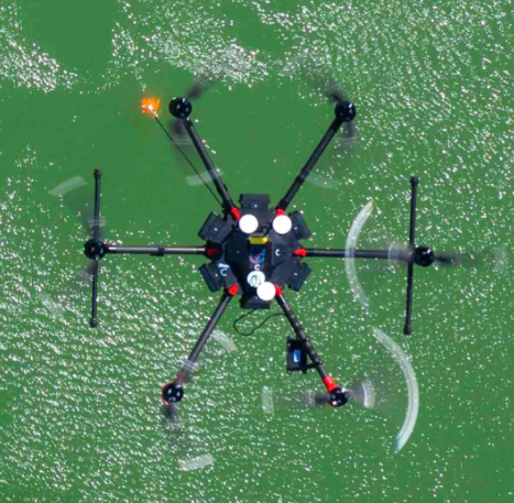
The drone methane detection & survey system from JBUAS, is an integrated solution that includes an eye safe class 2 laser from Pergam-Suisse. This system enables Tunable Diode Laser Absorption Spectroscopy (TDLAS), which records methane gas in Parts Per Million x Metres (PPMxM). By measuring the methane in this way, a better assessment of gas release is possible (compared to simple handheld readings).
Learn more about the drone methane detection sensor system here.

Falcon Laser Specifications
- Maximum detection range: up to 30 meters
- Measurement range: 1…50,000 PPMxM
- Threshold sensitivity at 30 m: 125 PPMxM
- Real-time data transmission: Yes, with UgCS SkyHub
- Programmable flight route: Yes, with UgCS Pro
- Maximum drone speed during operation: 50 km/h
- Geotagged Data: Yes, Input from drone via UgCS SkyHub
- Laser wavelength: 1.65 μm (safe for humans)
- Operating temperature: -17 … +50 °C
- Rain resistant: Yes
- Wind Envelope: Max. 20 knots (10m/sec)
- Power supply: Provided by UgCS SkyHub
- External unit dimensions: 100 × 82.5 × 80 mm
- Detector weight: 0.3 kg
- Full UgCS System Weight: 1.2kg
Flight Time & Area Covered
With a weight of 1.2kg, the methane detection system, when fitted to a M300RTK, will provide the pilot with 40 minutes of flight time. For comparison, expect around 20 minutes of flight time from M600 Pro. In an ideal scenario, a drone should survey 100 sqm in approximately 13mins (including turns). Make an enquiry to find out more.
Make an Enquiry
For further information, get in touch.