


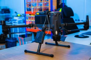
SPH Engineering – drone with SkyHub
SPH Engineering Systems vs Traditional Geophysical Survey Systems: A UK Perspective
Survey companies across the UK are under increasing pressure to collect more data, cover larger areas and deliver results faster than ever before.
Traditional geophysical survey systems continue to play an important role across sectors such as archaeology, utilities, infrastructure, environmental monitoring and engineering. However, many organisations are now exploring how integrated UAV technologies can improve operational efficiency, increase site accessibility and expand service capabilities.
SPH Engineering’s systems combine specialist geophysical sensors, automated mission planning, terrain-following technology and integrated data workflows into a single operational platform. This guide compares traditional geophysical survey methods with SPH Engineering’s integrated approach and explains why many UK organisations are adopting UAV-based geophysical systems.
Why Organisations Are Switching to Integrated Survey Systems
Traditional geophysical methods often require dedicated equipment, significant field time and multiple workflows to achieve project objectives. Modern integrated UAV systems help organisations to reduce field time on larger projects. By facilitating access to difficult or hazardous terrain, the use of drone technologies can reduce the health and safety risks to personnel. Through improved workflow repeatability, businesses reduce mobilisation costs and generate more reliable data.
For many organisations, the goal is not to replace proven survey methods but to complement them with more flexible technology.
What Makes SPH Engineering Systems Different?
Traditional survey equipment is often designed around a single application or sensor type. SPH Engineering takes a different approach, creating a complete ecosystem that combines software, hardware and specialist geophysical sensors into a unified workflow.
The SPH Engineering ecosystem includes:
- UgCS mission planning software
- SkyHub onboard integration platform
- True Terrain Following (TTF) radar technology
And a payload sensor from one of the following categories:
- Ground Penetrating Radar (GPR)
- Magnetometers
- Methane detection systems
- Echo sounding and bathymetry systems
The result is a scalable operational platform capable of supporting multiple applications from a single UAV system.
SPH Engineering Systems vs Traditional Survey Systems
| Capability | SPH Engineering Systems | Traditional Survey Systems |
|---|---|---|
| Survey Planning | Automated mission planning using UgCS | Manual grid and route planning |
| Terrain Accessibility | Excellent for difficult or inaccessible environments | Requires physical access throughout the survey area |
| Sensor Flexibility | Multiple sensor types from a single platform | Often dedicated to a specific application |
| Operational Consistency | Automated and repeatable workflows | Highly dependent on operator methodology |
| Health & Safety | Reduces personnel exposure to hazards | Personnel often work directly within the survey zone |
| Large Area Coverage | Efficient coverage of large sites | Can be labour intensive and time-consuming |
| Workflow Integration | Unified ecosystem | Multiple standalone tools and processes |
| Commercial Scalability | Easier to expand into multiple survey disciplines | Typically requires additional equipment investment. |
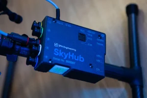
SPH Engineering – Skyhub
Traditional systems provide high-quality subsurface data but often require operators to physically access the survey area. SPH Engineering’s integrated drone GPR workflows combine a UAV platform with SkyHub onboard integration. SkyHub facilitates True-Terrain Following technology and UgCS automated mission planning software. Furthermore, SkyHub enables information captured from a payload to be saved as raw data on its internal memory, ensuring mission security against cloud hackers.
This enables organisations to deploy GPR in challenging environments while maintaining consistent, repeatable survey patterns.
Learn more about SPH Engineering Drone GPR workflows
Who Benefits Most from SPH Engineering Systems?
SPH Engineering systems are particularly attractive for organisations looking to diversify beyond traditional surveying approaches.
- Survey companies expanding beyond photogrammetry and LiDAR
- Engineering consultancies undertaking geophysical investigations
- Archaeological contractors
- Utility mapping organisations
- Environmental monitoring specialists
- Pipeline inspection providers
- Universities and research institutions
- Drone operators entering the geophysical sensing sector
UgCS: The Foundation of the Workflow
One of the key advantages of SPH Engineering systems is the ability to automate and standardise flight operations through UgCS. The benefits of universal ground control software include automated mission planning and true terrain-following flights. With repeatable data collection workflows, GIS, and mapping integration, UgCS helps users to maximise their flight capabilities.
Read the SPH Engineering UgCS Complete Guide
SkyHub: Integrating Sensors and Data Collection
SkyHub acts as the operational bridge between the UAV platform and geophysical sensors. It is an onboard computer which enables sensor integration, data acquisition, and TTF.
Learn about SkyHub Data Security
Maintaining a consistent flight height is essential when collecting high-quality geophysical data. SPH Engineering’s True Terrain Following technology enables UAVs to fly low and safely while automatically adapting to changing terrain. Some of the benefits of this capability include consistent sensor performance and improved data quality. Furthermore, TTF can lead to enhanced flight safety and improved operational efficiency.
Why Organisations Choose JBUAS
JBUAS is not a survey contractor. Instead, we help organisations evaluate, integrate and deploy UAV geophysical technologies through:
- System integration
- Equipment demonstrations
- Operator training
- Workflow development
- Technical support
- Test and validation activities
As the official UK partner for SPH Engineering, JBUAS enables survey companies, engineering consultancies and drone operators to add advanced geophysical sensing capabilities to their existing services.
Related Reading (Cluster Articles)
-
- What is SPH Engineering’s SkyHub, and how does it work?
- SPH Engineering UgCS for UK surveyors — complete guide
- SPH Engineering GPR vs traditional ground GPR workflows
- SPH Engineering methane detection: UK industrial applications
- Why SPH Engineering chose JBUAS as its UK partner
- How JBUAS and SPH Engineering Are Transforming UAV-Based Geophysics in the UK
Evaluate SPH Engineering Systems Before You Invest
Choosing the right geophysical survey technology requires more than comparing specifications. JBUAS helps organisations assess technologies, evaluate workflows and develop operational confidence through demonstrations, training and technical support.
Visit the JBUAS’s dedicated UAV Geophysical Test & Training Centre to compare traditional survey methods with integrated SPH Engineering systems.