Geolux RSS-2-AB water surface velocity measurement kit
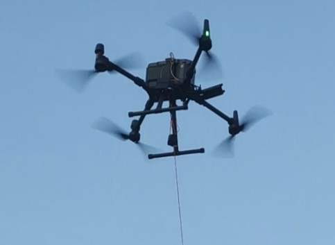
The Integrated System with Surface Velocity Radar uses radar technology to provide contactless measurement of surface flow velocity.
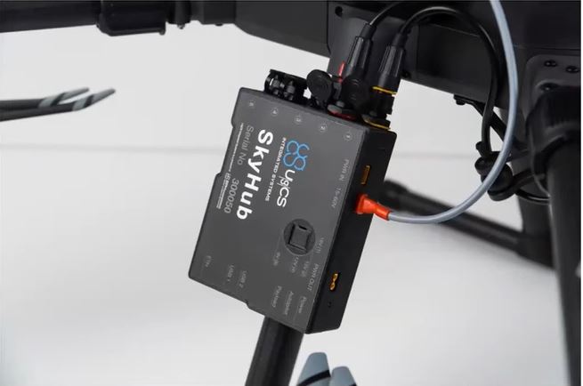
The main advantage of using a sensor on a UAV is the ability to perform measurements in hard-to-reach places without existing infrastructure. The entire process is automated thanks to the onboard computer SkyHub and UgCS Mission Planning software. The sensor installed on the UAV can perform measurements at a specified point.
This CSVR utilises a doppler radar that enables airborne measurement of surface flow velocity in rivers and streams at high spatial resolution. The radar (based on the Geolux RSS-2-300W), operates at the safe frequency – K band in the region of 24.125GHz. The system has all the necessary EN approvals.
Live Data
With connection directly to the UgCS SkyHub onboard computer, measured data is transferred in real-time to the survey crew. The bulk of the data is recorded safely on the SkyHub for post flight download and processing using the Geolux Configurator application.
How it works
Due to the doppler effect, the frequency shift between the transmitted and reflected electromagnetic wave is proportional to relative velocity between the radar instrument and the water surface. As the UAV is placed in a holding position while the measurement is being made, the frequency shift is proportional to the flow velocity of the water at the surface.
Applications
- Existing channel dataset validation
- Channel erosion investigations
- Water catchment flow behaviour
- Rapid catchment deployment missions
- Channel discharge monitoring
- General flood prevention studies
- Hydrological and hydrographic research,
- Environmental monitoring
- Engineering projects in water supply
The radar operates in K-band (24.075 GHz to 24.175 GHz), providing flow speed readings ten times per second.
For further infortaion, please get in touch for the technology development papers: info@jbuas.co.uk
Get in touch

Geolux LX-80-AB Water Level Measurement KIt
The Integrated System with Geolux Radar Level Sensor uses radar technology to provide a precise contactless measurement of the distance from the sensor to the water level.
The radar altimeter can be flown in autonomous mode at an altitude of 30-40 meters along the river and provides water surface elevation profiles with centimeter accuracy. Because water is an excellent reflector of microwaves, the radar return will be dominated by water targets.
Typical applications:
- Water level monitoring for rivers, channels, and lakes
- Water reservoir monitoring and irrigation control
- Observing the level of various fluids in the chemical industry
- Monitoring levels in wastewater, industrial applications
Link to UgCS in a separate window

UgCS SF Echosounder System
This ECT400S 450kHz single frequency system is easy to transport and deploy and has the ability to operate at hard to reach locations, unsafe or hazardous environment.
The drone makes bathymetric surveys 10 times faster and 2 times more cost-efficient compared with a standard approach using a boat or an unmanned surface vehicle (USV).
Drone deployed sonar allows acquiring seamless UAV bathymetry data of coastal and inland water bodies.
- 450kHz single frequency
- Operates in water depth 30cm to 100m
- Beam width Conical (-3dB): 5deg
- Solution weight: 2.4kg
- Hydromagic software bundle
- Drag and Grasshopper deployment
- Rapid set up within 10 mins
- Live data feed via UgCS SkyHub 3
- Suitable for M300/M350RTK
- Provides bathymetry data
Make an Enquiry

UgCS DF Echosounder System
This ECT DO52S duel frequency system is easy to transport and deploy and has the ability to operate at hard to reach locations, unsafe or hazardous environment.
The drone makes bathymetric surveys 10 times faster and 2 times more cost-efficient compared with a standard approach using a boat or an unmanned surface vehicle.
Not only does this system enable rapid UAV bathymetry data of coastal and inland water bodies, it can also investigate organic bed deposits like those found in sludge ponds and provide indications on river channel erosion or soft sediment deposit rates.
- 50kHz and 200kHz duel frequency
- Operates in water depth 1m to 200m
- Beam width Conical (-3dB): 27°/7° (50 kHz/200 kHz)
- Solution weight: 2.7kg
- Hydromagic software bundle
- Drag and Grasshopper deployment
- Rapid set up within 10 mins
- Live data feed via UgCS SkyHub 3
- Suitable for M300/M350RTK
- Provides bathymetry & soft sediment data
Link to UgCS in a separate window

Sound Velocity SWIFT SVP
The Valeport SWiFT SVP is a simple to use device which measures not only sound speed but also temperature. Water temperature by depth can be used to correct GPR bathymetry data, because speed of electromagnetic waves in the water depends largely on temperature.
- A speed of sound correction can be a requirement for engineering surveys as it is a direct contributor to the depth error and uncertainty.
- This sound velocity profiler is a relatively simple device, which measures speed of sound in the water at the depth of the sensor.
Link to Valeport in a separate window

UgCS Drone Water Sampling System
A UAV water sampling system for efficient and rapid deployment.
Traditional methods require direct access to the water body and samples are gathered from the shore, pier, bridge, or by boat. Acquiring samples at some distance from the bank without a boat or ship is now possible quickly. This UAV remote sampling system enables water sampling at long distances from the shore.
- Fully automated
- Sampling points precisely repeated
- Different sampling depths to suit need
- A few Km from shore within easy reach
Link to UgCS in a separate window

TOPODRONE Aquamapper
AQUAMAPPER is based on the tried and trusted UgCS SkyHub TTF core system architecture. It also utilises as standard the Echologger software for post-flight data processing. Using an onboard GNSS receiver, the position of the echosounder is known for accurate results. AQUAMAPPER is ideal for flying bathymetry missions on inland waterways.
- High survey speed up to 4m/sec
- Accuracy up to 5cm X,Y,Z
- Quick deploy, ready for use in 10 minutes
- PPK ready solution
- Open sea bathymetric survey up to 100m depth
- Weight 2.5kg
Link to UgCS in a separate window

QuickDip Search & Inspection Sonar Sensor
This sonar system is a rapidly deployable solution for freshwater applications such as those found in rivers, streams, and lakes, and saltwater applications such as tidal rivers, estuaries and coasts.
- This drone systems utilises UgCS SkyHub and can therefore store data with timestamps and geo-locations for post-processing.
- Answers questions previously only possible by deploying a remote submersible vessel or diving teams saving considerable time and cost.
- Made possible through the seamless integration of proven and trusted technology; UgCS Pro, UgCS SkyHub and True Terrain Following (TTF), Imagenex sonar technology at 300Khz and 800Khz.
Link to UgCS in a separate window
Make an Enquiry about a Sensor Solution
Make an enquiry to find out more about a sensor system. Enquire via the below enquiry button.