



Drone GPR Survey of Queen Maeve’s Cairn Demonstrates New Approach to Archaeology
JBUAS has supported a drone-based GPR survey of Queen Maeve’s Cairn in County Sligo, demonstrating the value of non-invasive UAV archaeology. Queen Maeve’s Cairn is one of Ireland’s best-known megalithic monuments. The vast stone cairn sits on the summit of Knocknarea and is traditionally associated with Queen Maeve, the legendary warrior queen of Connacht.
Despite its importance, the interior of the monument remains unknown. The cairn has never been excavated, leaving unanswered questions about its construction, internal structure and whether archaeological features survive beneath the extensive stone mound.
In 2025, archaeologist Sally Siggins, supported by an Archaeology Research Grant, investigated whether drone-based Ground Penetrating Radar could provide a way to examine the monument without disturbing it.
The project brought together archaeological expertise and specialist UAV geophysical technology, including a 150 MHz RadSys GPR system integrated with the UgCS SkyHub Terrain Following System.
Using drone GPR to investigate an unexcavated monument
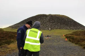
Queen Maeves Cairn – JBUAS
The primary objective of the research was to establish whether drone-based GPR could successfully survey a large hilltop cairn and identify potential internal features.
Unlike conventional archaeological investigation, the survey was entirely non-invasive. The team flew the UAV and GPR antenna no more than 5 metres above the monument, allowing them to collect data without physical contact with the cairn.
The challenging terrain meant that a conventional criss-cross survey pattern was not practical. Instead, the survey followed the edges of the monument using parallel flight lines, with additional flights across the top to capture a complete profile.
The drone was flown at approximately 1 metre line spacing and at a maximum speed of 1 metre per second. This approach was designed to maximise the horizontal resolution of the collected GPR data.
The survey data was recorded as GPR B-scans before being transferred for visualisation and interpretation. Further processing and the development of 3D C-scan visualisations are ongoing.
Challenging terrain for UAV archaeological surveying
Knocknarea presents a demanding environment for any archaeological survey.
The mountain is a popular hiking destination and is strongly associated with Irish mythology and heritage. Queen Maeve’s Cairn is located at the summit, while the lower slopes include distinctive geological and natural features.
Nearby, The Glen is a particularly unusual landscape feature on the southern side of Knocknarea. Atlas Obscura describes it as a tiny “microvalley” surrounded by steep rock walls and dense vegetation.
The surrounding terrain illustrates the combination of geological, environmental and archaeological characteristics that make the area both scientifically interesting and challenging to survey.
Atlas Obscura notes that Knocknarea is a popular destination because of its archaeological and mythological associations. However, The Glen remains relatively little visited.
For a UAV-based geophysical survey, these conditions make accurate flight planning and maintaining a consistent sensor height particularly important.
UgCS SkyHub and True Terrain Following
Maintaining a controlled sensor position above uneven archaeological sites is one of the key challenges when deploying GPR from a UAV.
The survey used the UgCS SkyHub system together with True Terrain Following technology to support accurate data collection across the uneven surface of the cairn.
JBUAS specialises in integrated UAV geophysical systems, combining drones with sensors, onboard computing and automated flight planning. The UgCS SkyHub platform is designed to collect and store sensor data while supporting specialist flight-control functions, including True Terrain Following.
For archaeological applications, this type of integration can provide a significant advantage. A UAV can follow a planned survey pattern while maintaining a controlled sensor height. This helps produce consistent and repeatable geophysical data.
Promising results for archaeological GPR
The 2025 survey successfully demonstrated that drone-based GPR can be used to investigate large hilltop cairns and identify potential internal features.
The preliminary results identified a number of anomalies that researchers are investigating further. The findings remain subject to additional surveys, data processing and verification.
The research report concludes that the technique has significant potential for archaeologists working on challenging, unexcavated sites and that further research is planned.
A non-invasive approach to archaeological investigation
One of the most important aspects of the project is its non-invasive nature.
Traditional archaeological investigation can require excavation, which may be inappropriate or undesirable for nationally important monuments. Geophysical techniques such as GPR provide an alternative way of investigating what lies beneath or within a site without physically disturbing it.
Drone deployment can extend this capability to locations where conventional ground-based surveying is difficult, including steep slopes, rough terrain and large monuments.
JBUAS has previously supported the development and application of drone-based geophysical systems for archaeology, including UAV magnetometry and GPR. The company has also worked with organisations interested in developing practical workflows for drone archaeology.
The Queen Maeve’s Cairn project demonstrates how these technologies can be brought together for a particularly challenging archaeological environment.
The future of drone-based archaeology
The successful survey at Knocknarea adds to the growing body of evidence that UAV-mounted geophysical sensors can provide valuable data for archaeological research.
For archaeologists, the ability to survey difficult or sensitive locations from the air could open up new opportunities for investigating monuments without excavation.
The Queen Maeve’s Cairn research is continuing, with additional survey work planned to further assess the methodology and provide greater confidence in the results.
As archaeological authorities and researchers continue to evaluate the findings, the project provides an important case study in the use of drone GPR for archaeology and demonstrates how UAV technology can complement established archaeological survey techniques.
JBUAS will continue to support the development of UAV-based geophysical survey technology for archaeology and other applications where accessing the survey area safely, efficiently and non-invasively is essential.
Further information on drone-based ground penetrating radar is available from JBUAS.