



SPH Engineering GPR UK: Drone GPR vs Traditional Ground GPR Workflows
Ground Penetrating Radar (GPR) is widely used across the UK for utility mapping, archaeology, environmental assessments, infrastructure investigations and geophysical surveys. Traditionally, survey teams have completed these tasks on foot using hand-held equipment. Today, SPH Engineering‘s integrated systems are providing UK surveyors with a powerful alternative through UAV-mounted Ground Penetrating Radar, enabling faster data collection, improved site accessibility and highly repeatable survey workflows.
In this guide, we compare SPH Engineering drone GPR workflows with conventional ground-based approaches and explore where each methodology delivers the greatest value for UK surveying, engineering and archaeological projects.
This article is part of the knowledge base set:
SPH GPR Workflows → SHP UAV Integrated Systems
Understanding Traditional Ground GPR Workflows
A conventional GPR survey typically involves an operator manually pushing or towing a radar unit across the survey area. The radar emits electromagnetic pulses into the ground and records reflected signals from buried objects, interfaces and subsurface anomalies. Surveyors process the datasets to create visual interpretations of underground conditions.
Traditional ground GPR remains highly effective where:
- Very high-resolution data is required
- The survey area is relatively small
- Ground access is straightforward
- Surface conditions are suitable for manual operations
- Flight operations are not practical.
Common applications include utility mapping, archaeology, pavement assessment, environmental investigations and infrastructure inspections.
What is SPH Engineering Drone GPR?
SPH Engineering’s drone GPR solution combines several technologies into a single integrated workflow:
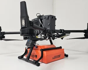
The Core System: GPR, SkyHub, and TTF radar.
- Ground-penetrating radar sensor
- UgCS mission planning software
- SkyHub onboard computer
- True Terrain Following (TTF) radar
- Compatible UAV platforms.
Together, these technologies enable automated survey flights while maintaining a consistent distance from the terrain below. This integrated approach helps improve data consistency while allowing surveys of areas that may be difficult, hazardous or time-consuming to access on foot.
Survey Planning
Traditional Ground GPR
Surveyors must establish grids manually before conducting ground-based GPR surveys. Operators typically use tapes, pegs, total stations or GNSS equipment to define survey corridors and collect data along planned traverses. This process can become labour-intensive on larger sites and may be influenced by site access constraints. Additionally, hazards such as rocks, holes, and vegetation can cause the operator to deviate from the course, resulting in poor mapping.
SPH Engineering Drone GPR
Drone GPR surveys are planned using UgCS software, enabling surveyors to create precise automated flight plans. The benefits include automated survey line generation, GIS and mapping data import. Accurate line spacing and efficient coverage of large sites are also important when it comes to generating missions that can be repeated at different stages of the survey project.
For organisations managing extensive infrastructure corridors or archaeological landscapes, automated flight planning can significantly improve operational efficiency.
Data Collection Efficiency
Traditional Ground GPR
Survey progress is dependent upon walking speed, terrain conditions and site accessibility. Challenges often include dense vegetation and uneven ground. Furthermore, steep slopes, wetlands and remote locations can make it extremely difficult to conduct ground-based surveys.
Larger survey areas may require significant field time and multiple operators.
SPH Engineering Drone GPR
Using automated UAV flight paths, data collection can be completed more efficiently and consistently. Advantages for personnel include reduced operator fatigue and easier access to challenging terrain. Environmentally, there is reduced disturbance to the survey area, whilst operationally, projects benefit from improved line consistency and faster deployment across large sites.
Drone GPR vs Traditional Ground GPR: Comparison Table
| Criteria | SPH Engineering Drone GPR | Traditional Ground GPR |
|---|---|---|
| Survey Planning | Automated mission planning with UgCS and repeatable flight paths | Manual grid setup and route planning |
| Site Accessibility | Ideal for difficult, remote or hazardous terrain | Requires physical access across the entire survey area |
| Coverage of Large Areas | Fast and efficient coverage of extensive sites | Time-consuming on large projects |
| Terrain Following | Maintains height automatically using SPH Engineering TTF radar | Naturally follows terrain due to ground contact |
| Survey Consistency | Automated flight paths improve repeatability | Dependent on operator consistency |
| Operator Fatigue | Minimal physical effort during data collection | Can be physically demanding over large areas |
| Health & Safety | Reduces time spent in potentially hazardous environments | Requires personnel to work directly within the survey area |
| Best Applications | Large archaeological sites, infrastructure corridors, environmental surveys and inaccessible terrain | Small sites, high-resolution investigations and restricted UAV environments |
| Integrated Workflow | Combines UgCS, SkyHub, TTF radar and GPR sensors into one ecosystem | Typically operates as a standalone survey system |
| Primary Advantage | Efficiency, accessibility and automation | Maximum data resolution in controlled conditions |
Terrain Following Technology
Traditional Ground GPR
Ground-mounted antennas naturally maintain a relatively constant distance from the surface because they remain close to the ground throughout the survey.
SPH Engineering Drone GPR
Maintaining a consistent height above the ground is essential for reliable drone-based GPR surveys. SPH Engineering addresses this challenge using its True Terrain Following (TTF) technology, which integrates with SkyHub and UgCS software to continuously monitor terrain beneath the aircraft. This enables the drone to automatically adjust altitude during flight while maintaining a stable survey profile over changing topography. This is a key advance over the DJI drone’s internal software, which only permits a fixed altitude in relation to the take-off zone.
To learn more about this technology, read our guide: How SPH Engineering’s TTF Radar Enables Safe Low-Altitude Flight.
Drone GPR for UK Archaeological Surveys
The UK’s archaeology sector is increasingly exploring drone-based geophysical survey methods to investigate large landscapes before excavation.
Drone GPR can be particularly beneficial where projects involve:
- Extensive archaeological sites
- Large development areas
- Scheduled monument investigations
- Pre-construction assessments
- Heritage landscape surveys
Automated survey workflows can improve coverage consistency while reducing physical impact on sensitive sites.
Drone GPR for UK Infrastructure Projects
Infrastructure organisations are increasingly assessing the benefits of UAV-based geophysical surveys. Potential applications include utility corridor assessments and pipeline route investigations. Transport infrastructure projects, renewable energy developments and flood defence schemes can also benefit from UAV GPR surveys.
Where site access is restricted or survey areas are extensive, drone GPR can help improve operational efficiency.
Health and Safety Considerations
Traditional Ground GPR
Ground-based surveys often require personnel to operate within active construction sites and remote environments with difficult terrain. Surveying waterlogged areas and dense vegetation are a risk to the safety of operators.
SPH Engineering Drone GPR
Drone surveys can reduce the time personnel spend in challenging environments by enabling data collection from a safer operating position. This approach may support improved health and safety outcomes for certain project types.
When Traditional Ground GPR Remains the Best Option
Despite the advantages of UAV deployment, traditional GPR remains the preferred solution in some situations.
Ground GPR may be more suitable where:
- Maximum resolution is required
- Survey areas are relatively small
- Overhead obstructions restrict drone operations
- Drone operations are restricted
- Site conditions favour conventional methods
Many organisations continue to use both methodologies depending on project objectives.
Why UK Surveyors Are Exploring Drone GPR
Surveyors face increasing pressure to deliver accurate results while improving productivity and maintaining high safety standards. Drone GPR workflows can support these objectives through improved survey efficiency and consistent data collection. By using automated flight planning, operators can reduce site access challenges and enhance the repeatability of a project to ensure accurate comparable data.
Combined with technologies such as UgCS mission planning and SkyHub integration, drone GPR provides a scalable approach to modern geophysical surveying.
Integrated Workflows Matter
The true strength of SPH Engineering’s drone GPR platform lies in the integration between software, hardware and survey sensors.
The complete ecosystem combines:
- UgCS mission planning
- SkyHub integration
- True Terrain Following radar
- Drone GPR sensors
- Compatible UAV platforms
This integrated workflow helps surveyors collect geophysical data consistently across a wide range of environments.
Conclusion
As the official UK partner for SPH Engineering, JBUAS supports organisations deploying drone GPR systems across archaeology, infrastructure, environmental monitoring and utility mapping projects. From system integration and UgCS mission planning to SkyHub configuration and operational training, we help UK surveyors unlock the full potential of UAV-based Ground-Penetrating Radar technology.
Related Reading (Cluster Articles)
- What is SPH Engineering’s SkyHub and how does it work?
- SPH Engineering UgCS for UK surveyors — complete guide
- SPH Engineering GPR vs traditional ground GPR workflows
- SPH Engineering methane detection: UK industrial applications
- Why SPH Engineering chose JBUAS as its UK partner
- How JBUAS and SPH Engineering Are Transforming UAV-Based Geophysics in the UK