Drone Ground Penetrating Radar (Drone GPR) – High Compliance have become the first company in the UK to invest in the full integrated UgCS drone based GPR System.
Drone Ground Penetrating Radar (GPR) – A Useful Tool for the Construction Industry
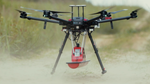
High Compliance have become the first company in the UK to purchase the UgCS Drone Ground Penetrating Radar (Drone GPR) system and this underlines their commitment to leading with innovation. The Drone GPR purchased is for utilities detection and will provide them with a tool that can access previously hard or impossible to reach areas. It is common in the construction industry for large areas to be surveyed prior to development andsome of these areas are not easily accessed with conventional systems. The Zond 500Mhz system will enable metallic and non-metallic utilities to be identified up to 5m in depth in typical soil. We look forward to updating the market on their trials of the system which we expect to take place in late April or early May 2021.
Bathymetry with Drone Ground Penetrating Radar (GPR)
The drone GPR enables to measure the depth of water or profiling the bottom of freshwater rivers, lakes, ponds up to 15 meters in depth. Benefits – possibility to do work even when the water is frozen or the surface of the water is partially covered with ice. Compared to bathymetry using a boat (equipped with echo sounders) the drone GPR provides better accuracy in following survey lines thanks to the inbuilt GPS and automated flight. Also, in most cases, a drone makes it a lot easier to deliver the necessary equipment to the desired area. Get data sets here.
Strat Profiling
Strata profiling is a standard task that needs to be done before any serious area development or construction works. The standard technique is drilling dozens of holes or conducting a GPR survey on carts. A Drone GPR integrated system delivers higher work productivity and enables safer work conditions for the personnel in cases of rough terrain. Drone GPR allows finding any potentially dangerous underground water streams or lakes. Get data sets here.
Utilities Mapping
Mapping of underground infrastructure is an important task before starting any construction works on previously developed territories or in cases when actual documentation and maps for underground infrastructure is missing. Get data sets here.
Drone Ground Penetrating Radar (Drone GPR)
About High Compliance
High Compliance are leaders in their field providing intelligent data using the latest drone and UAV technologies. They are the only drone specialist in the uk with their own API and Content deliver platform (CDP) portal. Their secure HiCData CDP and API is built on the latest video streaming and image data delivery technologies, allowing their customers to view, download and share their visual digital assets and data, with colleagues and stakeholders, anywhere at any time. True Innovators.